Places to Ride
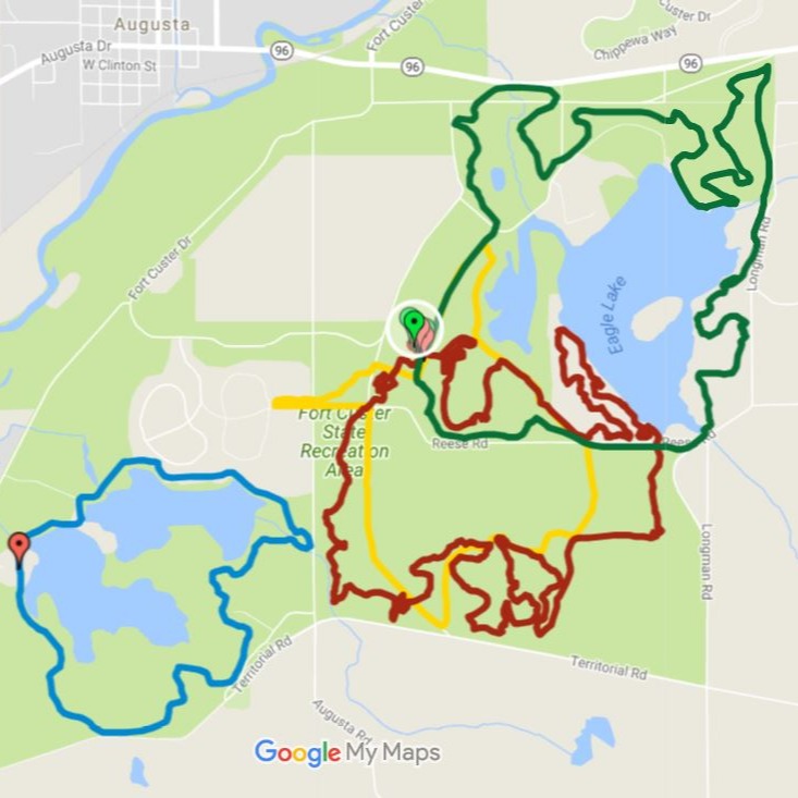
Fort Custer
The Fort Custer Recreation Area near Augusta, MI features four mountain biking trails of beginner and intermediate difficulty. The 4.2-mile-long Yellow Loop offers the most family-friendly experience, consisting of 95% doubletrack with no technical features and few moderate climbs, while the shorter but more difficult 3.6-mile-long Blue Loop offers many picturesque views in return for steeper climbs and descents. Do note that the Blue Loop is a multi-use trail that also includes equestrians, which do have right of way on the trail.
Fort Custer also offers two intermediate level mountain biking trails, the Green and Red loops. The Green Loops offers a challenging but rewarding 7.0 miles of hard-packed singletrack surface, which circumnavigates Fort Custer’s Eagle Lake. Depending on the day, the Green Loop can be ridden clockwise or counterclockwise for a refreshed experience. Not for beginners! Meanwhile, the Red Loop is Fort Custer’s longest but most feature packed mountain biking ride. At 8.1 miles of singletrack, the track has several sections at easy and intermediate difficulties, spotted with advanced technical sections that may require newer riders to dismount and walk past them. Ride both the Green and Red Loops together for an enjoyable 15 mile journey through the area!
Address: 5163 Ft Custer Dr, Augusta, MI, 49012
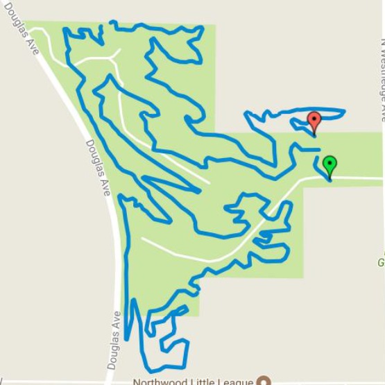
Maple Hill Trail
Machine-built by Spectrum Trail Design and managed by the Southwest Michigan Mountain Biking Association and Kalamazoo County Parks, the Maple Hill Trail in the Markin Glen County Park features almost five miles of singletrack suitable for riders of all skill levels. The trail incorporates many technical features designed to be easy for novice riders to roll through, but exciting and rewarding for intermediate and expert riders to take at higher speeds. Please note that Maple Hill Trail requires a Kalamazoo County Park Pass to enter, which costs $5 daily, or $25 annually. Follow the link below for more details on park passes.
Address: 5300 N Westnedge Ave, Kalamazoo, MI 49004
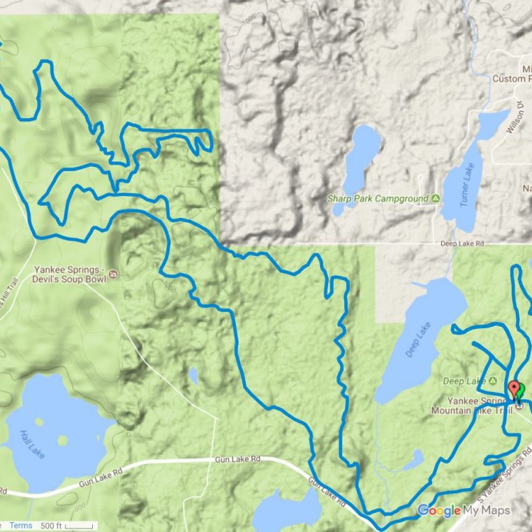
Yankee Springs
An intermediate-expert level trail, Yankee Springs is a long, 11.3 mile singletrack path that offers diverse terrains and backdrops across the path. Early parts of the trail pass through rocky climbs and fast downhills, which move into several switchbacks, and later through a section of pines packed with drops and climbs. Many small hills and climbs will keep you moving fast and working hard, for an overall fast-paced and rewarding mountain biking experience. Please note that the Yankee Springs Recreation Area requires a Michigan Recreation Passport for entry. Follow the link below for details on obtaining the passport.
Address: 2104 S Briggs Rd, Middleville, MI 49333
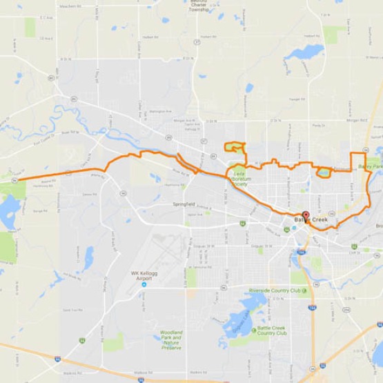
Battle Creek Linear Park
Battle Creek offers an admission-free paved path trail for cyclists, joggers, and casual strollers, totaling more than 26 miles in length. The park has no designated entry or exit points, anyone can hop on the trail at any convenient point they like, though they do recommend starting near Friendship Park in downtown Battle Creek, where plenty of free parking is available. For those looking to test their endurance, the Battle Creek Parks and Recreation Department developed six loops along the path, ranging from 1.0 mile to 10.5 miles in length. Please note that Linear Park crosses many streets which must be crossed with caution.
Address: Capital Ave NE, Battle Creek, MI 49017
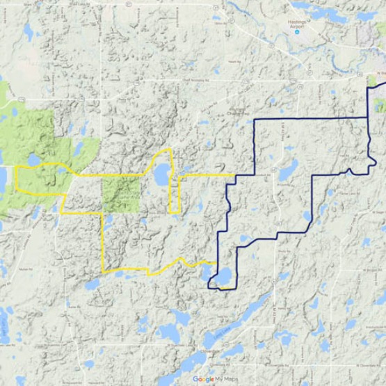
Barry Roubaix Course
Rather than ride a trail, mix up your cycling experience and participate in the Barry Roubaix gravel road bicycle race! The race welcomes cyclists in all categories from mountain to fat bikes, and offers courses of multiple lengths in 18 miles (blue), 36 miles (yellow) , and 62 miles (red). All the tracks traverse gravel roads spanning throughout Barry County, Michigan, offering scenic views and rolling hills to compete on. The Barry Roubaix gravel road race is held annually around the month of March or April.
Address: Downtown Hastings, MI 49058
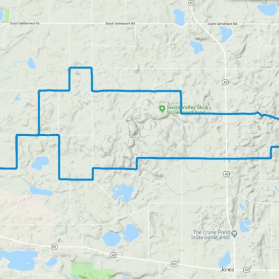
Melting Mann
Named after MANN road, the most difficult section on the trail, the Melting Mann Challenge held Saturday, March 23, 2019, is a dirt road challenge promising a worthy trial for bikers at every skill level. All three routes laid out over Cass County, Michigan consist of 90 percent unpaved, dirt road, with different routes stretching 24, 35, and an impressive 60 miles long. Trail maps and statistics are still being updated, but the 24-mile loop has over 1000 feet of vertical ascent, while the 35-mile loop has over 1500 feet of climb! The area also features Mount Misery, one of the highest natural geographical points in Southwest Michigan, and it’s accessible via MANN Road.
Because the course shares the open road with vehicle traffic, be sure to follow Michigan Vehicle Code and wear an ANSI/Snell approved bicycle helmet. Online registration closes Thursday, March 21, 2019, fees vary depending on date, age, and division.
Address: 18035 W. State Street
Vandalia, MI 49095
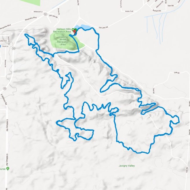
Hanson Hills Course
Hanson Hills features three single track trails, from three to eleven miles long, with one trail featuring alternate, expert-level sections. Located out of Grayling, Michigan, the over 20 miles of trail take one all over the beautiful Oak Forest. In the winter, Hanson Hills grooms a fat tire bike trail nearly six miles long out of snow, making the area accessible year-round. Trail access is seven days a week, 9 am to dusk, and includes a $2 per person fee via donation tube.
Address: 7601 Old Lake Rd. Grayling Michigan, 49738
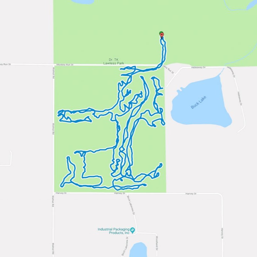
TK Lawless Course
An alternating-direction-per-day course, the TK Lawless course is an advanced skill level loop spanning ten miles of Cass County Parks. The loop is single track, with numerous twists, short climbs, straightaways, corkscrews, whoop ties, and downhills. The difficulty of the course comes from the length and the climbs more so than the technical sections, be prepared to ride for at least six miles before finding the first exit, and for around an hour and a half to ride the whole ten miles. The trail includes an admission fee decided by Cass County Parks, currently one dollar for county residents and three dollars for non-county residents.
Address: 15122 Monkey Run, St Jones, MI 49061
Hammond Hills
An intermediate difficulty trail, the Hammond Hills routes are all machine-built and multi-use, meaning bikers share the trail with walkers, runners, and just about anything short of a car. The total distance is 5 miles long, split up into plenty of fast sections with small jumps, but the trail is also bidirectional, for a total round trip of ten miles. There are twelve sections in the trail, with several branching paths, check out the map and plan your route!
Address: 578 Hammond Rd, Hastings, MI 49058
Calhoun County Trailway
In 2003, a committee was put together to plan a multi-use non-motorized trailway to span Calhoun County. Funded through community donations and constructed in 2015, the Calhoun County Trailway currently spans a 5.6 mile section from the Historic Bridge Park to the Battle Creek Linear Park. The path accommodates all non-motor traffic, from cyclists to runners to casual strollers, and passes through the beautiful Kimball Pines and Ott Biological Preserve, offering amazing and secluded views of Michigan’s diverse wildlife. Dotted with pavilions, benches, and bridges, the Calhoun County Trailway offers an enjoyable experience for every traveler.
Address: 904 Emmet St. E, Battle Creek, MI